
Deployment of tethered UAV allows us to measure vehicle counts and other important parameters over a continuous and uninterrupted period of time. With the traffic data obtained, we can get a comprehensive overview of the conditions of traffic roadways and junctions. Read the original article HERE.
Volarious specialises in actively tethered system for compact-sized drones and is the trusted choice for public safety and first responders. Volarious tethered system offers an unlimited flight time of 12 hours and beyond, which is highly essential in recording uninterrupted drone footage for the traffic study. Designed to be compact with a heavy-duty protective casing, V-Line offers unmatched convenience and portability making it suitable for even the most rugged-terrain for drone operation.
Volarious has partnered with GoodVision in using automated traffic video analytics with their tethered drone platform. Both companies prepared a detailed video guide to bring you through the procedures to obtain the desired results for your traffic monitoring and analytics. Watch the full webinar video below:
About GoodVision
GoodVision Video Insights is an advanced traffic analytics platform that helps transport modellers and traffic surveyors to achieve incredible productivity in traffic data analytics. GoodVision offers a one-stop-shop for all the analytical tasks the transportation industry requires and makes your daily work more enjoyable.
In this article, you will learn:
- Understand the key points for preparing for a traffic study and using the Volarious V-Line Tethered System for unlimited flight time
- Familiarise with using the GoodVision Video Insights traffic analytics platform to gather insights from the traffic data

1. Planning for the shoot
Before going to the traffic site, we plotted out the distance and the area of traffic site we wanted to capture and made sure it is within the covered field of view of the drone. (The field of view is mentioned in the video and seen in Fig. 1)
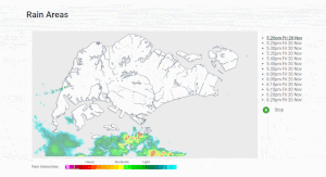
We checked the weather before going to the traffic site. (Fig. 2)
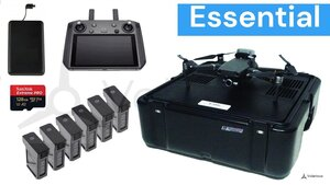
2. Things to Bring
- Mavic Drone with RC Smart Controller*
- Portable Charger with Type-C cable
- V-Line Tethered station with V-Line Power Module
- x6 TB47S Batteries*
- SD Card
- GoodVision Video Insights platform account, which you can get at my.goodvisionlive.com
A set of fresh set of batteries is x6 TB47S Batteries will last for two hours long. For long operation, you may choose to bring more fully-charged set of TB47S batteries. Alternatively, you can bring an AC generator.
3. Configuration
Keep camera angle from -90 to -45 degrees ideally if you plan to analyse pedestrian traffic too. If you are looking for a higher drone shot of vehicular traffic, you can keep the drone at a straight down angle. We flew the drone within the variable distance of 15–30 meters from traffic site. We recorded the video with 24 FPS and resolution of 4K. By following this guide, you will get the most suitable traffic footage videos that can be used for processing and analytics.

4. Traffic Analytics In GoodVision Video Insights
Recorded drone footage was uploaded and processed with GoodVision Video Insights. The platform provided us with a very clear view of the traffic flows on the junction. Our video was 2 hours long and divided into 20 separate video files. We were impressed how simple it was to upload the footage, as GoodVision’s platform manages it all automatically and stitches all your files without your necessary intervention. A bonus was, that GoodVision automatically stabilised all drone videos and removed all drone movements caused by the strong wind.
“GoodVision’s traffic analytics platform is so powerful and easy to use. It is just the right tool for anyone looking to collect and analyse traffic data quickly and easily.”
(Douglas Wong, Volarious)

Clear distinction of traffic lanes allowed us to precisely select traffic movements our client needed to analyse. From the drone survey, we were looking to obtain the following parameters:
- Multimodal traffic counts
- Vehicle speed
- Vehicle gaps on each entry to the junction
All of these parameters we were able to obtain very precisely in the matter of seconds in the platform, and it was also exported in the Excel report vehicle by vehicle. This way we have saved a significant amount of time on traffic data collection versus the manual traffic counters our clients were using before. The detail and granularity of traffic data provided by GoodVision is unreachable for any conventional method to deliver.
Both solutions are available to users globally. Please reach out to us at info@goodvisionlive.com if you want to know more.
Read more success stories of our clients: